 Understanding crab movement throughout different seasons is critical information in the management of Bering Sea crab fisheries. For instance, it tells us what habitats are important for crab and which habitats they use at different times of the year. For many years, researchers have studied where crab move using tags attached to crabs captured at sea. Researchers affix tags to captured crabs, release them and then wait for the crabs to be recaptured. Their location is documented when they are caught again and then researchers know where they travelled since tagging. This method only tells us two positions: where the crab was when it was tagged, and where it was when it was recovered. Recovery times and locations are also limited to when/where there is a fishery. These methods are typically limited by small sample sizes from very few tag recoveries.
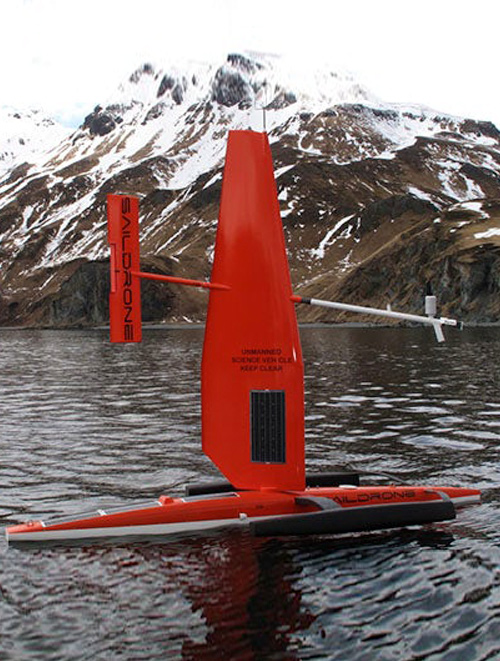
To gather more information about other locations where crabs go between tagging and recovery, BSFRF scientists are collaborating with NMFS research partners Dr. Bob Foy and Dr. Leah Zacher to use new technology this summer. The new technology uses VEMCO acoustic tags that communicate with unmanned drones that sail on the surface of the water. These Saildrones look like small sail boats. As they sail on the sea surface near tagged crabs, the Saildrones receive a ‘ping’ from the tags on the crabs. The Saildrones can then collect location data on these crabs without needing to recapture them. This method of releasing tags that “talk back” to a receiver has the ability to greatly improve sample sizes where multiple positions could be received from a single tagged crab once they are located by the Saildrone. In addition, the Saildrone can be sent out in different seasons in any location, so data are not restricted to when and where there is a fishery.
In June, BSFRF captured Bristol Bay red king crab during summer surveying (see article below) using pots. A total of 148 captured crabs were tagged and released and two “marker tags” were set out as reference points, attached to weights and dropped to the seabed. For each of the 148 red king crabs, tags were attached with a harness looped through a muscle in the back of the carapace, so the tags will be retained through crab molting. Each tagged crab had its tag “switched on” so that it began pinging, and the pings were tested for reception as each crab was released. In October, two Saildrones will be deployed from Dutch Harbor to sail out to the study grounds to relocate crabs that were tagged in June. The study is designed to determine crab movement from June to immediately prior to the commercial fishery which typically opens October 15. In March-April, 2020, the Saildrones will again be deployed to relocate tagged crabs and continue monitoring crab movement. All vessels are asked to avoid the Saildrones to ensure they remain undamaged. Any commercial fishermen that captures a tagged red king crab should note the capture coordinates and tag number and quickly release it unharmed back into the water in the same location in was captured. If it is possible to measure the length and get a shell condition (soft, new, old shell), that information will also be helpful, but only if it can be done quickly without harm to the crab. Only if the crab is dead or heavily damaged should the tag be removed and returned to the researchers. The contact info of researchers to report Saildrone sightings or tagged crab encounters are; Dr. Leah Zacher (project lead for NOAA) reachable at , (907) 481-1730 work. Scott Goodman of BSFRF can also be reached at , (206) 285-3480 work, and (425) 232-5986 mobile.
Please stay tuned as BSFRF and NOAA will be conducting outreach related to this research in July 2019 through April 2020 to alert harvesters about the research project. Other research partners, including Alaska Department of Fish and Game and the Alaska Bering Sea Crabbers will assist in getting the word out to the fleet.